How to Navigate Using Stars and Constellations
How to Navigate Your Way Using Celestial Breadcrumbs
Do you know how to navigate using stars and constellations? You’re marooned in a small life raft. You’re stranded for two blinding bright days and two very dark nights, waves of an unforgiving ocean are crashing around you. Without a moon, the blackened dome above your head stretches to every corner of the horizon speckled with thousands of tiny points of light, like pinpricks in a black canvas tarp.
Knowing Where You Are
Sweeping across the expanse is the disc of the Milky Way, a dense concentration of stars and gases. Each night, these stars swirl in a familiar pattern as the Earth turns on its axis. Gazing up at these stars, the universe may feel immense, but the ocean surrounding you is colossal; land, hidden by the curvature of the Earth, is out there somewhere. But where?
Without a compass, a map, or other seafaring gear used to discern the direct way home, you are lost—but you are not alone. Within you, deep inside the far reaches of your DNA lurks the knowledge and knowhow of your seafaring ancestors who used little more than the stars to travel thousands of miles. Learning how to navigate using stars is important.
History of Celestial Navigation
Stories were spoken around campfires. Mankind relied on the ocean for travel and food. However, observant men discovered some stars stayed in the same spot every night. Others danced around them as they appeared and disappeared under waves at the same place on the horizon night. Equipped with this knowledge, they used these specific stars as guideposts that helped point them toward a specific destination. If they kept a star in a specific place relative to their boat, they could maintain a steady course.
Soon, enterprising craftsmen developed tools to measure angles between certain stars and the horizon. With a little bit of math, they could figure out their latitude (how far north or south they were). Early seafaring cultures used crudely drawn maps with their extensive knowledge of the heavens above. Their charts showed major sea routes, likely winds, and traditional currents. They could leapfrog from one point to another via nearby islands,, all, under the guidance of the stars.
City dwellers will need to escape the light pollution for the opportunity to see star-filled skies. (Photo by Unsplash/Denis Degioanni)
Different Cultures
Navigators from Eastern cultures were using the stars to exactly pinpoint precise locations over great distances of the oceans using the early concepts of latitude and longitude long before Europeans even considered it an option. When the West reached China, they were amazed at the detail the Chinese mariners had in their maps. The Europeans took the astronomical knowledge of the Chinese and combined it with their own skills and mechanical knowledge to create the earliest practical sextants and seagoing chronographs, which allowed sailors to accurately determine both latitude and longitude. These accomplishments took thousands of years and were built on the knowledge and experience of many different cultures.
Regardless of these milestones in the history of celestial navigation, one merely needs a clear night sky, some basic knowledge of the stars and constellations to navigate using stars, and the willingness to trust that a small blink of light trillions of miles away will lead you toward home and safety.
Navigation Waypoints
Northern Hemisphere: Although there are many ways to persuade Mother Nature to help you find your way during the day, there are only a handful of methods you can employ to find out which way is north at night. In the northern hemisphere, the easiest way to find north is to look for the North Star (aka Polaris). This single star has been used for thousands of years by untold navigators to point them north because this star hangs in the sky almost directly over the North Pole (it’s about ¾ of a degree off) like the hub on a wheel, never moving in relation to the spin of the Earth. Since it sits at the top of the sky, its position will change very slightly during the night.
In the Southern Hemisphere, locating the Southern Cross is the first step to determining location. (Photo by Unsplash/Andrew Preble)
North Star
Now some of you may be asking, how do you find the North Star? Since we were children, the easiest “constellations” for us to see are the Big and Little Dippers, probably because they made the most sense. They are water ladles instead of mythical creatures and millennia-old deities. Finding Polaris is easy once you’ve located the Big Dipper. Two stars form the outer edge of the dipper’s bowl, Merak and Dubhe. Connect those two stars with a line, and then merely extend that line up and away from the Big Dipper. The next major star that intersects that line is Polaris. You’ll be headed north in no time.
IN SPITE OF ALL THE SCIENTIFIC AIDS THAT HAVE BEEN DEVELOPED TO DO THE NAVIGATING BY ROBOT SCIENCE, THE ANCIENT STARS WILL STILL BE A ‘MUST’ FOR NAVIGATOR OR PILOT. —HENRY NEELY, ASTRONOMER

Southern Hemisphere: For people in the Southern Hemisphere, they can’t see Polaris. They’re facing away from it. For them, the major navigation waypoint is the Southern Cross. It’s a grouping of four stars that forms a distinct cross shape. First described to westerners by Amerigo Vespucci during his southern voyage in 1501, the “Four Stars,” point directly south. Following down the long axis of the cross for a distance of approximately five times its length. You will be at a point that is directly above the southern pole.
Their Movement Points to Direction
There is a secondary method for determining the direction from the stars. Look at the movement of one of them over a short period of time. Start by locating the brightest star in the sky (that isn’t Polaris). For example, the brightest star is Sirius, which is located in the southern sky for people in the Northern Hemisphere and high overhead for those in the Southern Hemisphere.
Find a way to track the star’s movement. An effective way to do this is by clocking the star with two sticks in the ground. Look over the top of the two sticks to line up their tips with the star you chose. After about 20 minutes, note where the star is in relation to the two sticks. If the star moved up it is in the East. Consequently, if it moved down it is in the West. If it moved left it is in the North and if it moved right it is in the South. These rules apply to the northern hemisphere, so reverse them for the southern hemisphere.
Stars Can Determine Location
Our ancestors journeyed farther and farther from home. They searched for new lands, new avenues for trade, and new resources for growth of their civilizations. These people realized that knowing the direction of travel was only half of the problem. They needed to know location, too. Knowing where you are in relation to where you want to go and where you came from helps plan more efficient and safe voyages. This involved knowing latitude and longitude, a grid of imaginary lines that trace around the globe to show position.

Even with a campfire going, explore the starry sky when you are in remote locations.
The first half of this pair of numbers is the latitude. It is measured from 0 degrees at the Equator to 90 degrees at the North or South Poles. The North Star stays above the northern pole. Conversely, the Southern Cross is above the southern pole. The angles between the horizon at sea level and these two stars is the same as your latitude. Zero degrees on the Equator, 90 degrees (straight up) at the poles, and something in between elsewhere on the globe.
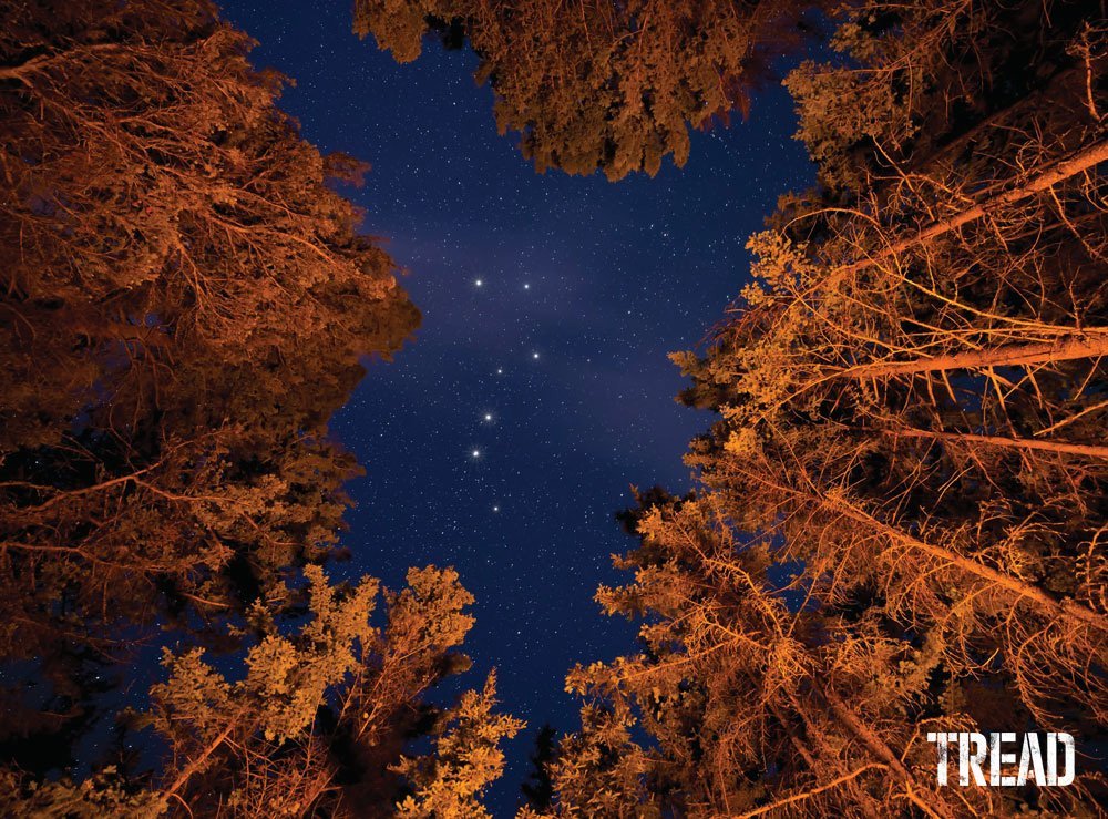
The Big and Little Dippers are used to locate Polaris, or the North Star. (Photo by Unsplash/James Wheeler)
Measuring your latitude can be done accurately using a sextant. However, an estimate can be made using your fist and an outstretched arm. Your outstretched fist makes an angle of close to 10 degrees. Position the top of your fist directly under the North Star, and with one fist under another. Measure how many “fists” it takes to reach a horizontal position. For example, if it takes three and a half “fists,” you are 35 degrees above the Equator.
KNOWING WHERE YOU ARE IN RELATION TO WHERE YOU WANT TO GO AND WHERE YOU CAME FROM HELPS PLAN MORE EFFICIENT AND SAFE VOYAGES.


Longitude Learning
The second half of that positional pairing, longitude, is a little more difficult to ascertain. You need a reliable timepiece. This is why accurate longitudinal measurements on the open ocean weren’t possible until the invention of a reliable chronometer in the 1700s. A reasonable estimate can be made with simple rudimentary math.
Longitude is measured from 0 degrees at the Prime Meridian in England through to 180 degrees on the opposite side of the Earth. The Earth spins on its axis at a constant rate of 15 degrees per hour. You can multiply the difference in hours between the time at the Prime Meridian and your local time by 15 degrees. Know your longitude. For example, Denver is in the Mountain Time Zone, which is seven hours behind the Prime Meridian. Seven multiplied by 15 degrees is 105 degrees longitude. You can see how difficult locating your exact longitudinal position is based solely on simple math. A typical time zone is just over a thousand miles wide (at the Equator). That’s not a very small ballpark.
Let the Stars Guide You
Electronics break, batteries die, and the things we use to make life easier fail every day. Learning how to use the stars. Finding your direction or crudely ascertain your rough location are skills that we should all develop. You don’t want to be stuck in the dark on a life raft in the ocean. Which way you paddle might mean all the difference. Remember the warnings from astronomer Henry Neely. “In spite of all the scientific aids that have been developed to do the navigating by robot science, the ancient stars will still be a ‘must’ for navigator or pilot.”